 |
| Winter 2002 |
Vol. XI, No. 1
|
|
In This Issue:
This issue of the Conservation Almanac is being funded in part by grants from the
State Water Resources Control Board, EPA, and the Department of Conservation
Rural Roads & Erosion Workshop
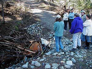
The South Fork Coordinated Resources Management Planning Group and the RCD sponsored a free workshop on February 9th in Hayfork on Rural Roads and Erosion. Danny Hagans, a Hydrologist with Pacific Watershed Associates, presented information to assist landowners in making decisions about their roads. The workshop included a slide show depicting various types of road designs and potential problems, along with a chance to get out in the
field to see and discuss examples of road related erosion problems. It also identified well designed roads that tend to reduce maintenance costs and minimize the amount of sediment that is delivered to the streams, which negatively impacts the fishery.
Topics discussed included:
- Overview of watershed erosion processes
- Overview of forest and rural roads
- Road and hillslope drainage
- Road stability--problems and solutions
- Maintaining, winterizing and storm-proofing rural roads
The presentation was very informative and provided landowners with information they found useful to bring back to their road associations and how to improve the roads on their own property to protect their investment in the road as well as to protect the fishery habitat downstream.
This workshop, which was funded by Fish & Game, EPA, and the Department of Conservation, revealed the fact that roads are a major source of erosion and sedimentation. Road surfaces increase the rate of runoff, and road cuts intercept and bring groundwater to the surface. Ditches concentrate storm runoff and transport sediment to nearby stream channels. Culverted stream crossings can plug, causing fill wash outs or gullies where the diverted stream runs down the road and hillslopes. Roads built on steep or unstable slopes may trigger landslides.
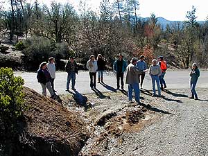 |
Discussing road erosion in the field
In spite of this, road construction does not have to result in excessive erosion and downstream sedimentation. Proper planning, design and construction techniques can prevent water quality problems and can significantly extend the useful life of the road. Even roads that are poorly designed can be upgraded to lower maintenance costs and reduce sediment to creeks.
The handbook distributed to participants in the workshop, called Handbook for Forest and Ranch Roads, A Guide for planning, designing, constructing, reconstructing, maintaining and closing wildland roads states, "Good planning, proper location and the use of progressive construction practices can largely avoid the impacts normally associated with road building. Do it right, and you will end up with a low-maintenance, low-impact road. Do it wrong, and you are destined for high maintenance costs and high environmental impacts."
Building a stable road should be viewed as a long-term commitment of both resources (cash and equipment) and time. If you are unable to make that commitment, then the road either should not be constructed, or it should be built as a temporary road with drainage structures that are removed after use.
Preventive measures can really pay off. This includes:
- Checking existing culverts before & during storm events
- Constructing waterbars or rolling dips to improve drainage
- Excavating unstable fills and sidecast
- Clearing trash barriers and inlets
Danny reminded landowners to contact the RCD or NRCS, if they need technical assistance with their road to improve drainage and reduce sediment delivery to streams.
Return to this Issue's Index |
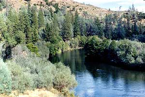
South Fork Trinity River Watershed Restoration Summary for 2001
 |
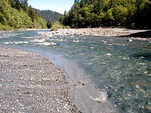
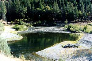
Excavated Stream Crossing
The RCD's Implementation Coordinator, Cynthia Tarwater, recently completed a summary of the watershed restoration work that took place during the summer of 2001 in the Upper South Fork Trinity River Watershed. This project was funded by a grant from the California Department of Fish and Game's SB-271 program. This work included road maintenance, hydroclosures, and decommissioning on US Forest Service lands adjacent to the Yolla Bolly Wilderness.
It was determined that nearly 17 road miles were upgraded, which included installing larger culverts designed to withstand a 100-year storm, constructing critical dips at crossings, and other road drainage improvements in order to keep roads functional over the long term. Over 5 miles of road have been hydroclosed or decommissioned, which involves excavating culverts at stream crossings, thus minimizing the potential sediment delivery that could occur if the pipes fail due to excess flow or debris.
Other projects that took place in the South Fork included a road inventory on private lands in Grouse Creek watershed in cooperation with Timber Products and the South Fork CRMP, as well as erosion control along the PG&E transmission easement.
This was a successful season for South Fork Trinity River Watershed Restoration and more work is being planned for 2002.
Return to this Issue's Index
Watershed Coordination Activities
Since March of this year, the Trinity County Resource Conservation District has been actively involved in Watershed Coordination in the Trinity River and the South Fork Trinity River Watersheds with funding from the California Department of Conservation. These grants have enabled us to play an important role in assisting stakeholders in developing watershed restoration priorities and in seeking the funds to implement them.
South Fork Trinity River Watershed
The RCD continues to participate in the South Fork Coordinated Resource Management Planning Group. South Fork CRMP efforts currently include the development of a monitoring program to assist landowners and land managers; developing road and erosion control workshops; coordinating partners in securing funding for restoration work in the South Fork; and meeting with individual landowners to discuss concerns about the watershed.
The draft water quality monitoring plan has been distributed to SFCRMP members and the priorities continue to be discussed. Over this winter sediment and turbidity samples have been collected and analyzed at over 30 sites. There has been a concerted effort to get a wide range of samples following storm events from as many locations as access is available.
The SFCRMP has just hosted a Road and Erosion Workshop in the Hayfork Valley for landowners. See the associated article on page 1-2.
The RCD along with the Post Mountain PUD and Volunteer Fire Department will be hosting a Fuels Reduction Workshop at the Post Mountain Fire Hall on White Oak Road on April 6th at 10 am. to show landowners how to effectively make property fire safe. Our Registered Professional Forester, Ken Baldwin will demonstrate how to do a sample mark of vegetation to be removed, while explaining the reasons for each selection. Workshop participants will have a chance to do their own sample mark, with feedback from the forester. An RCD crew will then demonstrate tree falling and brush cutting techniques and slash disposal methods, by chipping and burning.
Trinity River Watershed
The RCD has been central to coordinating stakeholders interested in the Trinity River. The Trinity River Restoration Program has entered a new phase. The Trinity Management Council, composed of agencies and tribes, is responsible for implementing the program.
The District helped form the Trinity River Watershed Working Group earlier this year, and has used this group to help interested parties stay involved in the restoration of the Trinity River. The Working Group has emphasized the need for on-the-ground restoration in watersheds, like Rush, Grass Valley and Indian Creeks, recognizing that the overall health of the Trinity River cannot be achieved without healthy tributaries.
Late last year the RCD and the Working Group sponsored community and technical workshops with the U.S. EPA on their new sediment rule for the Trinity River.
Return to this Issue's Index
|
Frequently Asked Questions:
Trinity River Fisheries
Restoration Program
Q: Before the dams were built, the river would get much lower in the summer than it is now. Why do summer flows have to be so high, wouldn’t it be more natural to mimic historical low summer flows?
A: It’s true that in general, late summer flows are now higher than prior to completion of the dams. However, historic flow records show that in some years, river flows at Lewiston were much greater in June and July than they have been after the dams were constructed. Before the dams, salmon such as spring chinook could move upstream to cooler streams such as Stuart’s Fork, Coffee Creek, etc. to spend the summer. In addition, pools below the dams were deep and stratified with cold water. With completion of the dams, up to 109 miles of prime fish habitat was lost and the pools below the dams filled in with sediment. Higher summer flows are now necessary to maintain cool water habitat for spring chinook.
Q: Will the restoration affect my favorite fishing hole?
A: Probably not, though if your spot is in, or immediately downstream from, a restoration site, it may be affected. One negative impact of the dam was that fine sediment filled in many historic deep pools on the Trinity. With higher flows and healthy gravel bars the river is likely to create many new fishing spots.
Q: Will extra water in the river mean lower water in Trinity Lake? Will my favorite boat ramp be left high and dry?
A: According to the analysis in the Environmental Impact Statement, the impact of the availability of boat ramps due to the change in flows for the restoration program will be minimal. Of the total days available for use due to lake levels, the new flow schedule will cause a decrease from 0% to 3% from the existing levels.
More FAQs in the next newsletter….
|
A Current View of the
Trinity River and Restoration,
continued...
By Brandt Gutermuth,
BLM Trinity River Coordinator
The Trinity River Mainstem Fishery Restoration Record of Decision (ROD), which was adopted as the Department of Interior's plan for recovery of diminishing Trinity River fish stocks in December 2000, includes a biologically based set of restoration objectives such as gravel addition, increased river flows, and mechanical reshaping of the river's channel. However, to efficiently move forward, we need to determine cost-effective techniques for completing the work. For instance, to efficiently build the bank restoration sites, we need to survey the selected areas and to design the earth work to be done. Then, we need to work with the large cast of environmental permitting groups (e.g., the California Department of Fish and Game, the North Coast Water Quality Control Board,the National Marine Fisheries Service, etc.) to make sure that our intended plans meet environmental standards set for the River.
 |
- Constrained
- Overgrown
- Flow limited
|
 |
- Dynamic
- Complex & Variable
- Flow sustained
|
Trinity River--Above and Below North Fork Trinity (at Helena)
After environmental clearances (permits) are obtained, I expect that we will test various restoration techniques on one or two of our priority sites. A phased implementation of these initial sites may first allow us to develop off-channel wetland and riparian habitats. Then we will remove the present sand berm to allow river communication with the floodplain, again. At these pilot sites, invaluable practical construction and permitting lessons could be learned, including how best to minimize the amount of construction sediment that reaches the river. If we approach this next phase of Trinity River restoration as a research project to determine specifics for implementing all measures of the ROD, then, when Trinity River flows are increased, we will truly be able to gain the most habitat (for fish and wildlife) from a limited resource (Trinity River allocated flows)!
This article is a continuation of an article Brandt wrote for the last issue of the Conservation Almanac . Brandt can be reached at (530) 623-5104.
Return to this Issue's Index
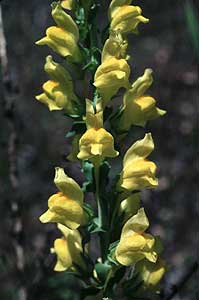
Noxious Weeds to Watch in Trinity County
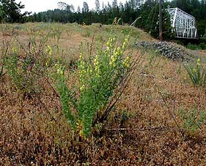
Dalmatian toad-flax (Linaria genistifolia ssp. dalmatica)
Dalmatian toad-flax is a hardy perennial that was introduced as an ornamental from the Mediterranean region. A short-lived perennial, toadflax spreads by seed and lateral roots. The taproots are large, rough, somewhat branching, and may extend down 6 feet. The deep taproot of this plant enables it to survive our hot, dry summers in Trinity County. Long slender lateral roots branch from the vertical roots and may extend 10 feet or more, remaining close to the soil surface. Buds that develop on the lateral roots produce new shoots. Infestations of this weed generally form large colonies from this extensive root system. Once established, high seed production and the ability for reproduction by the lateral roots allow for rapid spread and high persistence.
 |
Dalmatian toadflax, which has no value as forage and may contain a poisonous glucoside harmful to livestock, crowds out valuable food for wildlife and livestock. Plants, growing up to 3 feet tall, have bright, showy, yellow flowers that resemble snapdragons, and wavy, egg-shaped leaves that clasp the stem. A mature plant can produce up to 500,000 seeds annually, and they can remain dormant for up to ten years. This plant flowers from May to August and produces seed from July to October. Fortunately, most seeds end up close to the parent plant. Some seeds are spread short distances by wind and great distances by water, soil movement, and by clinging to feet, fur, and tires. It is not surprising that Dalmatian toadflax is generally found along the highways and in highly disturbed areas in Trinity County.
Toad-flax is an extremely difficult plant to control because of its root system. Successful control can be obtained by pulling before toadflax seed production begins. Intensive cultivation for at least 2 years (every 7-10 days the first year and 4-5 cultivations the second year) will deplete energy reserves in the roots and may offer hope to those with small populations. Since the seeds can remain dormant for up to ten years, the site must be checked every year and new sprouts removed for at least ten years to completely remove a stand. Competitive perennial grasses and forbs should be planted to utilize water and nutrients that would otherwise be readily available to toadflax. Vehicles should avoid areas infested with dalmatian toadflax whenever possible because this causes the greatest threat of spread of this noxious weed.
Return to this Issue's Index |
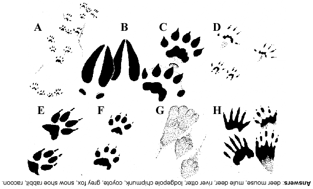
Tracks & Habitat Game for Kids
Each clue below tells about an animal that lives in our area. Can you guess the name of each animal from the clue and track given below? (Please note, the tracks pictured are not actual size!!)
- This small furry animal eats berries, seeds, mushrooms and insects. Its tiny tracks are often not as clear as the ones pictured below.
- This animal eats only plants (an herbivore) and has large ears. The males have antlers.
- This mammal loves to swim and play in rivers. It eats fish, snakes, birds and eggs.
- This mammal is the size of a mouse but has stripes on its back and tail.
- This track is often confused with the domestic dog. This animal is often heard yelping in groups at night.
|
- This animal is smaller than a coyote. It lives in a den and is mostly active at night. It eats small mammals, birds, fruits, and nuts. Often it’s noted for its bushy tail.
- Another herbivore, this species changes its fur color from brown to white during the winter to stay hidden from coyotes and other predators.
- This mammal gets much of its food from the water so its tracks are often found near streams. Its known for its black “mask” and black rings on its tail.
|
|
Habitat Activity
People and other animals all share some common needs such as shelter, water, food, and enough space to live. All these things together in the right amounts form an animal’s habitat. One way to find out about an animal’s habitat is by looking for its tracks. This is an excellent time of year to look for tracks. Wait for the day after a fresh snowfall. In the morning, go out in your yard or ask an adult to take you to a place to look for tracks.* How many can you identify? Where does it look like the animal was going and what was it doing (gathering food, going to its home, running from another animal)? You may also want to check out a book on animal tracking from your library.
* If you don’t want to wait for fresh snowfall, ask an adult to take you to a river or trail where there is soft ground, mud, or sand to look for tracks.
Return to this Issue's Index
RCD's Newest Americorps Members
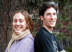 |
Elizabeth & Joel share their enthusiasm with the District
|
| You may have already seen Elizabeth Gill around the county teaching school children about watersheds down at Sydney Gulch or out by Coffee Creek. She began working with the RCD last fall through the AmeriCorps Watershed Stewards Program. Originally from Michigan, Elizabeth grew up outside of Detroit. She attended the University of Michigan in Ann Arbor and graduated in 2000, with a Bachelor of Science in Natural Resource Ecology and Management.
After school Elizabeth started her work with the AmeriCorps Watershed Stewards Program in Fortuna. There her activities focused primarily on fieldwork such as conducting spawning surveys, stream monitoring and riparian restoration. She chose to do a second year in Trinity County because of the area’s beauty, the “real” seasons, and the small town atmosphere (although she says it could use a good Thai restaurant). Elizabeth’s interests include hiking, playing guitar, singing, and knitting. She’s also an aspiring snowboarder and enjoys extended bike trips. “Hopefully this summer I’ll be able to take some long weekends backpacking in the Trinity Alps too.” Since moving to Weaverville she has enjoyed learning the local natural history and meeting people in our community. Elizabeth is considering a career in urban planning and design.
|
Meet Joel Silverman, the RCD’s newest AmeriCorps staff member. An Idaho native, Joel graduated in 2001 from Evergreen State College in Olympia, Washington. His most notable experience at Evergreen, was his research in Belize and Guatemala; where he studied the effect of conservation efforts on the native inhabitants.
After graduation Joel worked in New Mexico at Bandelier National Monument monitoring the effects of fire. He is interested in learning about the intricacies of fire ecology and its role in plant succession. He strongly believes that “in the future we are going to have to look more closely at the function fire plays in the ecosystem and how we can use it as an effective management tool.”
Joel was attracted to the Weaverville AmeriCorps site for many reasons. The RCD offers a variety of interesting projects including environmental education, restoration and fire monitoring. He is also an avid botanist and is excited to learn more about the plant ecology of Trinity County. At first Joel was a little apprehensive about moving to such a small town, but now he is appreciating the character and history Weaverville has to offer. He is also enjoying the slower pace here and is taking advantage of it by writing letters, baking bread, and cross-country skiing with friends.
|
| Return to this Issue's Index
|
District Manager's Corner
by Pat Frost
Winter is the season when we take stock of how well we planned the rest of the year. With each approaching storm I look out my window and ask myself whether I am ready for winter. Did I put up enough firewood? Are the chains in the vehicles? Did we clean out the culvert under the road?
The same is true here at the District. We spend most of the year implementing conservation projects; restoring stream banks, seeding and mulching disturbed slopes, up-grading and storm proofing forest roads, all with an eye towards preparing our watersheds for winter. Now is the time for us to get out and take stock of those projects. We are collecting water samples to monitor the effectiveness of our erosion control work in the Oregon Mountain and Lowden fires. Our staff go out and inspect projects — Are the rolling dips reducing the diversion of water? Is the native grass seed germinating and holding soil in place? Are last year’s streamside plantings holding the banks in place? Did the larger culverts that we installed carry the flow of bigger storms? How much sand is being captured in the Hamilton Ponds?
Every year we help landowners implement conservation practices on their land and in their streams. And every year we learn something new. The goal of the District is to provide the best technical support to you that is available. If you have a resource problem be like the landowner up Ritterbush Gulch, who saw the dirt in his driveway washing into the North Fork of the Trinity River during a storm last summer. Give us a call. This winter the North Fork of the Trinity has less sediment in it, because of that one phone call.
Return to this Issue's Index
Return to the Trinity County RCD Home Page
|