 |
| Winter / Spring 2000 |
Vol. IX, No. 1
|
|
In This Issue:
Impacts of Roads
 |
An expensive road to nowhere?
Roads can have a tremendous impact on the health of our watersheds. Roads are beneficial in that they provide access for residences, recreation, and management, and may also work as fire breaks. However, roads that are poorly designed, or poorly located can result in significant problems to the quality of water and health of the fisheries. Improper design and grading of roads leads to erosion and often requires costly regular maintenance.
Road erosion and washouts are a problem for many residents of Trinity County. This is especially true for those living along unpaved roads in the more mountainous areas. Steep slopes and heavy rainfall (or rain on snow) combine to cause soil instability, erosion, and drainage problems which can pollute streams with sediment, damage or destroy roads, and threaten other property as well.
Roads increase soil erosion by the alteration of natural drainage patterns. One of the main mechanisms by which this is done is through collection/concentration of runoff from the hillside. In many instances roads collect water from a wide area of hillslope, runoff that would normally be diffused across the land on its way down to a waterway below. However, a road may create a kind of dam, an unnatural barrier at which all of the water is stopped, then redirected (by means of an inboard ditch for example). Thus a large amount of water is concentrated at specific crossing points, often the site of a natural stream crossing. This concentration of runoff increases the likelihood of culvert failures due to debris and sediment and other problems during storm events. Such failures create environmental damage and necessitate costly repairs. The cost of repairs to a failed road greatly outweighs the costs of regular upkeep and preventive
maintenance.
Another problem that is compounded by collection/concentration of runoff is the increased amount of sediment that is delivered to our streams and rivers. Roads are much more prone to erosion than the undisturbed land on which they were built, due to the disturbances in hillslope continuity and vegetative cover. Runoff water picks up exposed soil as it passes over, and delivers it in concentrated form to the road’s stream crossings. When these crossings are natural creeks or other waterways, then all of this extra sediment is being delivered directly into the region’s stream and river system. This has significant impact on the salmon habitat in our County and the lands of our downstream neighbors—sediment settles out in the streams and rivers and chokes the spawning gravels that are vital for salmon reproduction. Increased turbidity (sediment content) in our waters harms not only salmon and other native fishes, but also ourselves, as
it fills up dams, clouds our drinking water, and carries our fertile soils out to sea.
Unpaved roads are major contributors of sheet, rill and gully erosion, as well as landslide erosion. Paved roads, however, are also a significant problem. Cutbanks, plugged culverts, and increased concentration of water runoff raise erosion rates and sedimentation.
The US Environmental Protection Agency (EPA), through its Total Maximum Daily Load (TMDL) process, as well as other regulatory agencies, are showing concerns about the high levels of sediment reaching both the South Fork and mainstem Trinity Rivers. Most counties have enacted some type of grading ordinance to be able to achieve proper road and building grading techniques in order to reduce erosion.
 |
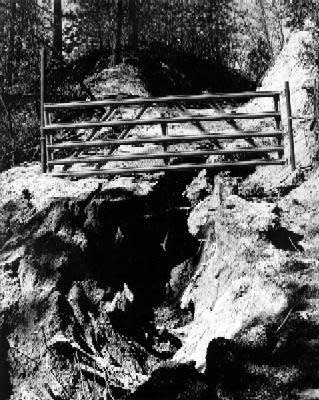
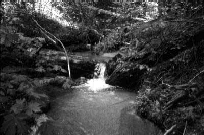
Failed culverts are a common road-related problem
In Trinity County there is currently no grading ordinance; however, such a regulatory measure may be implemented in the near future by the County Planning Department in order to make sure all roads and projects conform to responsible standards.
Steps taken to reduce the sediment and improve fisheries include road upgrade, maintenance, and/or closure. Road upgrades include installing larger culverts where needed, constructing rolling dips, and removing diversion potential.
Planning and building new roads, as well as repairing and maintaining existing roads, are activities that require careful planning and implementation. There are many factors involved in choosing where, when and how to build.
This article has covered some key points among these issues; however, we urge you, whether you are a landowner planning some kind of development, a contractor or equipment operator implementing such projects, or an otherwise concerned citizen, to further educate yourself about responsible road building and maintenance techniques.
The Trinity County RCD will soon be hosting a series of evening workshops that seek to provide you with more information.
Return to this Issue's Index |
Trinity County Grading Ordinance
by Mark Lancaster, Trinity Co. Planning Dept.
Over the past 2-3 years, a lot of attention has been given to water quality problems from grading and sediment delivery to local streams. Now, the tough issue of a local grading ordinance has come to the forefront. The EPA has determined that human-caused sediment levels are too high in local river systems and they have begun the slow but inevitable process of setting allowable sediment levels for each river (see related article on the TMDL process). The National Marine Fisheries Service and fisheries biologists have said that high sediment levels can clog salmon spawning gravels reducing fish reproduction. A 1998 University of California Cooperative Extension assessment of land uses in Trinity, Humboldt, Del Norte and Siskiyou counties found grading and sediment problems in our county.
Unfortunately, we have also seen grading for homesite development that has impacted water quality, altered drainages, degraded septic leach fields and/or created hazards for construction of homes. On the other hand, we know that there are a lot of skilled operators needing little or no oversight to do a good job and that there has been quality grading projects throughout the county.
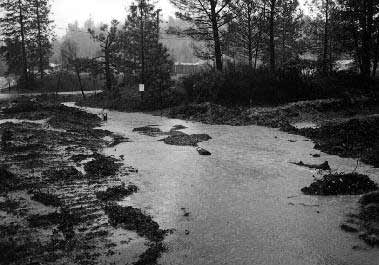 |
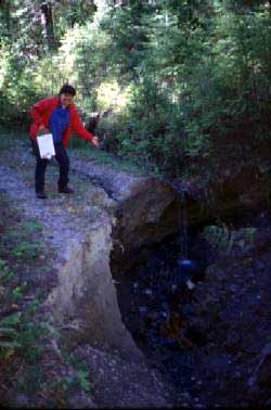
An erosion problem at a construction site
Can we create a balanced approach to address grading problems while relying on the experience of grading operators combined with additional education and training? The Trinity County Planning and Building Departments think so and are proposing an incentive-based grading ordinance that balances the need for safe construction, clean water and minimal government intrusion. There are no model ordinances that I know of that regulate risky grading practices without also snaring operations that are not problems or present no risks. In developing a solution to sediment and construction problems we can break grading into various categories based on resources at risk, and use certified grading practices that reduce those risks. That way, it could be possible to require grading permits and engineered designs only when necessary.
Many practices would be exempt from either certification or permitting. Activities that could be exempted include grading under a timber harvest plan or similar county or state permit, annual crop cultivation, routine road maintenance, road rocking, undergrounding utilities to homes or other buildings, repair of underground facilities, dredge mining, some gravel mining, and minor grading such as lawns or gardens where the drainage is not altered.
Free Grading Workshops Coming This Year
The RCD will hold a series of free workshops in 2000 for landowners, contractors and equipment operators. The workshops will focus on controlling erosion associated with road building and other grading practices.
Erosion from construction sites is a source of sediment in our rivers and streams. Much of it is preventable. Best management practices (BMP) can be used to reduce erosion from construction sites. Preventing erosion helps protect our streams and local fisheries. Participants, who successfully complete the workshop, will receive an Erosion Control BMP Manual and certificate of completion. For more information please call us at 623-6004.
These workshops are a cooperative effort with Trinity County, as a part of the Five-County Coho Plan, and are being funded though a grant from the U.S. Environmental Protection Agency.
|
Other, more complex, grading practices can be certified by the county as best management practices (BMP’s), exempting operators from having to get a grading permit. Certain grading operations, such as pad construction designed for buildings, road construction, conversion of forest or woodland to crop land, and grading near streams or watercourse could require a grading permit depending on the specific conditions.
Last year the EPA, in looking at sediment sources in a portion of the Eel River drainage, found that the most active land managers in the watershed, the timber industry, had significantly reduced sediment and risks of road failure over the past 15 years. The reasons for the road related sediment reduction were better road design, improved grading practices and proper control of drainage. They also found that the percent of human-caused sediment contributed from small landowners’ roads and county roads was increasing. If we can create a process that educates grading operators on the “tricks of the trade” to reduce erosion and avoids costly permitting to landowners, we can help operators to put money into improvements and not permits, and we will all be a little bit ahead in that case.
Preliminary work on an incentive-based ordinance has begun and the public and operators are encouraged to get involved in the effort. For more information please contact me at mlancaster@trinitycounty.org or by calling (530) 623-1351.
Mark Lancaster is an associate planner in the Natural Resources Division of the Trinity County Planning Department. He is the principal planner for the Five Counties Salmon Conservation Planning Committee and a Registered Professional Forester.
Return to this Issue's Index
Trinity River Sediment Total Maximum Daily Loads
Levels of sedimentation in the Trinity River and associated tributaries were judged by EPA and the North Coast Regional Water Quality Control Board (NCRWQCB) to exceed the existing Water Quality Standards necessary to protect the beneficial uses of the basin, particularly the cold water fishery. Accelerated erosion from past and present land use practices and natural sources impacts the migration, spawning, reproduction, and early development of cold water fish such as spring and fall run Chinook salmon and steelhead trout. The mainstem and South Fork Trinity River watersheds are included on California’s Clean Water Act Section 303(d) list as water quality limited due to sediment. This listing begins a process that leads to the adoption of allocations on the amount of sediment that can be put in the river and its tributaries, and to an implementation plan for meeting those limits.
The EPA committed to develop total maximum daily loads (TMDLs) for 18 rivers in northern California by December 31, 2007 as a result of a lawsuit filed by the Pacific Coast Federation of Fisherman’s Associations. The South Fork Trinity River TMDL was completed by EPA in December 1998. TMDLs for other areas of the basin are scheduled for completion in 2001. The purpose of these TMDLs is to identify sediment loading targets that, when implemented, are expected to result in meeting applicable water quality standards for sediment.
The components of the TMDLs include: Problem Statement-including assessment of instream and upslope conditions Instream Numeric Targets-intended to represent acceptable conditions for cold water fish Analysis of Significant Sediment Sources-past and present impacts on streams Linkage Analysis-to assess the magnitude of impairment and associated levels of sediment source reductions necessary to address the problem Allocation of Loads-to distribute needed load reductions among various sources
 |
TMDLs are developed by reviewing and analyzing existing data on instream resources and desired conditions. Implementation and meeting the targets of the TMDL is the responsibility of the NCRWQCB
Numeric targets for the South Fork Trinity River watershed were developed based on literature sources, existing data, and best professional judgment. An analysis of sediment sources was conducted to determine sources and quantities of sediment being delivered to the stream system utilizing air photos, computer modeling, and erosion rates based on scientific literature to estimate sediment production over time. This analysis estimates that sediment delivery to the stream averaged 1,053 tons per square mile per year over the period 1944-90. The South Fork TMDL generally concluded that an overall improvement of about 30 percent from the historical sediment-loading rate would achieve target conditions. The goals of this TMDL include fish population recovery, channel form and structure recovery, improved quality of spawning gravel, as well as decreased sediment delivery.
The mainstem Trinity River watershed TMDL is in the planning stages. Data are currently being collected at many tributaries in the watershed in an effort to provide better insight into the sediment problems in the Trinity River.
This information will help the EPA and local communities understand which tributaries have the most significant problems, and what sources of sediment could be controlled. Studies elsewhere in northwestern California indicate that road networks, including private dirt roads and driveways, can be significant sources of sediment in streams. Well designed and properly maintained roads pose much less of a problem. The RCD will continue to monitor the development of the mainstem TMDL and will keep you informed of opportunities for community involvement. You can also can get more information at EPA by calling Chris Heppe at (707) 825-2311 or
http://www.epa.gov/docs/region09/water/tmdl/index.html.
Return to this Issue's Index |
| Common Terms
Anadromous: fish that are born and rear in fresh water, mature at sea, and return to freshwater to reproduce.
Cross road drain: a deeply cut ditch, excavated across a road surface, which drains the road bed and inboard ditch.
Culvert: a transverse drain, usually a metal pipe, set beneath the road surface which drains water from the inside to the outside of the road.
Cutbank: the artificial face or slope cut into soils or rock along the inside of a road.
Diversion potential: a stream crossing has diversion potential if, when the culvert plugs, the stream would back up and flow down the road rather than over the crossing and back into the natural drainage.
Erosion: the dislodgement of soil particles caused by wind, raindrop impact, rilling, gullying, ravelling and other surface processes.
Grading: the act of excavating and moving soil along the road alignment to an established grade-line during road construction or pad preparation.
Runoff: rainfall or snowmelt which flows overland across the surface of hillslopes and along roads.
Sediment delivery: percent of material eroded from a site which actually gets delivered to a stream channel.
Turbidity: refers to clarity of water measured by the extent to which light passing through water is reduced due to suspended materials, such as silt and clay. Increasing turbidity is visually described as an increase in cloudiness.
For additional information refer to: Handbook for Forest and Ranch Roads, by Pacific Watershed Associates (1994); and Guide to Building Small Roads, by Soil Conservation Service (now NRCS) (1983). |
Road Inventories
A General Explanation
For the last several years the District has been involved with several road inventories in areas of the South Fork of the Trinity River. The objective of any inventory is to gather information on current road conditions. A data sheet is developed to collect and compile data into a format, which can be easily entered into a spreadsheet.
 |
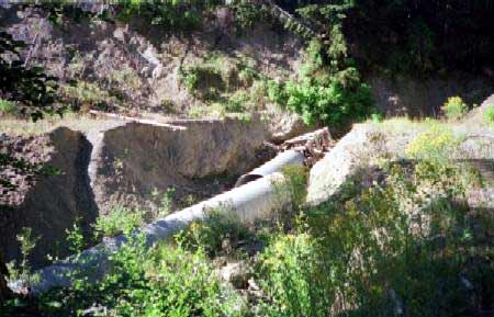
Road problem discovered during an inventory
Road inventories are designed to: Accurately locate and place on a map all roads in the watershed Station all roads for future maintenance or reconstruction. All culverts are recorded (stream crossings and cross-road drains) Collect the necessary data to evaluate the adequacy of stream crossing culverts and to calculate an approximate volume for each stream crossing in the watershed Locate all stream crossings with diversion potential (defined as a condition where a stream would leave its defined channel if the culvert plugged or water exceeded the culvert’s capacity) Identify road drainage and culvert maintenance needs, and document all active sediment sources associated with roads
Prior to collecting field data, all existing information on roads in the inventory area is compiled. This information is used to develop a base map for inventory crews to take into the field. In the field, roads are stationed (given mile markers) using measuring devices, all intersections, culverts, and active erosion sites are recorded by mile marker. All culverts are inspected for flow restrictions. If any exist, the site is recorded and flagged for future inspection and maintenance.
The final product from an inventory is a database containing information on current condition, ownership, as well as a summary of site data for each road. A revised base map is developed with all roads and stream crossings identified by mile marker.
From an inventory, landowners can identify existing problems or where problems may arise in the future. The inventory is used to prioritize projects based on need, benefit (in terms of potential sediment savings) and costs.
Return to this Issue's Index
AmeriCorps Volunteer at RCD
We’d like to introduce Justin Martin, an AmeriCorps Watershed Stewards Project (WSP) member who recently joined us here at the RCD. Justin began work with us here in January, and will be working throughout the year on projects related to watershed restoration and management.
Justin is a recent graduate from the University of Oregon, where he earned a Bachelor of Sciences degree in Biology. His interests in the field are widespread. He spent part of his later years at UO working in a mycological research laboratory, where his work focused on detailed genetic examination of several strains of fungus that are found growing in the needles of coniferous trees. He also enjoyed volunteering for a local non-profit, leading groups of children on walks through natural areas of a city park and teaching them about the intricate and fascinating workings of nature.
 |
Justin Martin, AmeriCorps Watershed Stewards Project
After his graduation Justin worked for several months on an organic farm near Eugene, taking a break from the more academic lifestyle of college. He then joined the AmeriCorps Watershed Stewards Project, an organization that is based in Fortuna, in Humboldt County. This group recruits volunteers with strong scientific backgrounds and assigns them to placement sites with various organizations throughout northwestern California. Justin and his fellow WSP members, including three others currently living in Trinity County, provide a valuable source of aid in salmon and watershed restoration efforts throughout the north coast region. This includes many projects involving community outreach and education.
Justin will be helping the RCD with several projects in the near future, including working on organization of an upcoming series of road grading workshops, as well as helping to design an interpretive trail for a riparian area near Weaverville Elementary School. He is also looking forward to helping to organize this year’s Salmon Festival. In addition to his work with the RCD, Justin will be working on some projects at the Trinity County Planning Department, such as designing a website for the Five Counties Coho Plan. Besides his interest in biology, Justin also pursued studies in anthropology and Spanish. He enjoys travel, and is especially fond of Latin America. He took some time off in college to travel by bicycle through several remote regions of South America, where both his Spanish and bicycle repair abilities increased greatly. One day he hopes to return for further adventure, and perhaps to live and work for a while.
For now he is enjoying the relaxing lifestyle he finds in Weaverville. “I’m used to bigger towns, having lived in Portland and then Eugene. It’s nice to be somewhere for a while where the pace is a bit slower and more relaxed. I’m finally getting to read all those books I’ve been meaning to get to, and I can actually keep up on correspondence with friends.” In his spare time, Justin also enjoys listening to music and gardening, as well as many outdoor recreational activities. He has already been snowshoeing, snow camping, mountain biking, and hiking in the area. He looks forward to doing more backpacking and exploring the nearby Trinity Alps this summer.
Return to this Issue's Index
An Introduction to BMPs for Road Design
In the design of forest and rural roads, it is important to take into consideration road surface drainage in order to maintain road stability and protect water quality. There are certain guidelines that can be followed in road design and implementation which outline the most effective way to prevent or reduce sediment runoff and road failure due to drainage problems. These guidelines are known as Best Management Practices, or BMP’s. They are not a set of regulations that have been imposed by any agency, but rather a recommended set of standards which have been reached through consensus and experience by resource professionals in the relevant fields.
Here are some examples of Best Management Practices for sediment control on road construction and maintenance projects:
· Outsloping - creating an outward slope of the road surface helps to eliminate many of the problems with roads that collect water in an inboard ditch
· Rolling dips - also known as “rolling the grade,” this design feature helps ensure that surface runoff will not concentrate on the road surface and erode the roadbed; it also helps to disperse the runoff in lower concentrations at more points along the road
· Outlet protection - any point where water is discharged (from rolling dips, culverts, etc.) should be protected from eroding by rip rap, vegetation, or other adequate measures to dissipate the water’s energy
· Road surfacing - placement of some type of road surfacing, such as shale, is preferable to help prevent erosion of the road surface
· Clean fill material - fill material from cutbanks or other sources should be free of large organic debris, which can be a potential source of fillslope failure
|
District Manager's Corner
by Pat Frost
Local landowners and resource managers started districts like our Resource Conservation District in the late 1930s. The focus of their attention was soil and water conservation – essentially the protection of these important resources from the impacts of excessive erosion. Those first soil and water conservation districts sprang up from the ruins of the dustbowl and they provided technical assistance to landowners to protect their property. They gave them lessons on better management practices that reduced erosion, that improved the use of property and that protected waterways for beneficial uses.
The setting and circumstances have changed over time, but the importance of minimizing soil erosion and protecting the quality of our resources is still with us. Nothing is more fundamental to our quality of life than the quality of our water. Winter in Trinity County is a great time to observe how we are doing with respect to soil erosion and the effects of that erosion on our rivers and streams. Drive down almost any road during a winter rain and you can see the forces of nature at work. Everyone has seen a ditch full of muddy water or a creek running the color of chocolate milk.
Don’t get me wrong – erosion is a natural process. What I am talking about is the higher rates of erosion that occur, because of our own actions. Roads and their construction can be a major factor contributing to the problem. Roads are designed for a purpose. We build them to get from one place to another more quickly and efficiently. We build them to concentrate our travels on specific routes. That same efficiency and concentration is seen in the way that roads handle rainwater. Roads move water quicker than a forested hillside or a grassy meadow, and roads concentrate the flow of water along one path. The impacts of combining roads and rain can be very costly– damage to the roads themselves costs landowners when they have to repair their roads each spring. Rainwater loaded with soil dumping from our roads into our streams and rivers carries many costs, too. It threatens our water supplies; it can reduce the capacity of the streams to
carry flood water, causing more storm damage to private property and public facilities; and it has dramatic effects on fisheries habitat.
This issue of the Conservation Almanac is dedicated to roads, erosion and what we can do together to make sure that Trinity County’s roads have minimal impact on the very resources that brought us to Trinity County in the first place. Today’s Resource Conservation District is rooted in its history. We are still dedicated to providing technical assistance and education to landowners. In the coming months we will be offering short workshops around the county on dirt road building and maintenance, and grading practices. I encourage landowners, contractors and equipment operators to attend.
Return to this Issue's Index
Return to the Trinity County RCD home page
|