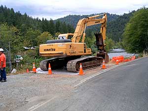
Construction to Start on Trinity River Bridges
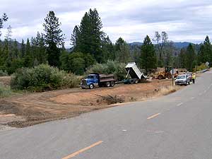
Construction is beginning at four road crossings of the Trinity River to prepare for releases from Lewiston Dam of up to 11,000 cubic feet per second (cfs) to enhance and maintain fishery habitat. Bridges at Biggers Road (off Steel Bridge Road), Poker Bar and Salt Flat will all be replaced, and the west approach road to the Bucktail Bridge on Browns Mountain Road will be raised. Construction schedules show contractor mobilization and the start of construction at all sites during July and August, with all four crossings completed and opened to traffic by the end of this calendar year. Detours will be established during construction to maintain access.
Designs for the bridge crossings were prepared by the U.S. Bureau of Reclamation (Reclamation), with project funding provided by Reclamation, the Central Valley Project Improvement Act Restoration Fund, and the California Department of Fish and Game Salmon and Steelhead Trout Restoration Account. The Trinity County Resource Conservation District will be responsible for designing and implementing revegetation of the sites with native plant species after construction is completed.
The 6-person crew worked for 10 weeks to complete 5.3 miles of foot trail maintenance, 3.7 miles of road brushing, 8.4 miles of jeep trail brushing, under the direction of a US Forest Service trail supervisor for training, layout, project supervision and support (pack stock, vehicles). The project was implemented in the Tule Divide Drainage with the objective of linking trails to roads to provide loop systems for access by recreational groups or fire crews. Trail rider groups out of the Indian Valley Station, hikers, and mountain bikers periodically use these trails.
Efforts are also underway to identify and address possible impacts of the higher flows to other structures in the floodplain such as homes and access roads. Designs are currently being prepared to raise approximately 1.1 miles of road in the Poker Bar area that will be inundated by some of the fishery releases. Inundation maps of the river are being prepared from Lewiston Dam to the North Fork Trinity River. Property owners will be notified if it is believed that they could be adversely affected by the higher flows which could be implemented as early as the spring of 2005.
These activities are being performed through the Trinity River Restoration Program Office located at 1313 South Main Street in Weaverville (next to Tops Market). The Executive Director of the program is Doug Schleusner who can be reached at 530-623-1800. If you have any questions specifically concerning the floodplain modification program you can call Ed Solbos at 530-623-1802.
|