|
| Fall 1999 |
Vol. VIII, No. 4 |
|
In This Issue:
Trinity County Fire Safe Council Responds to Fire Risk
Homeowner Fire Safety Guidelines
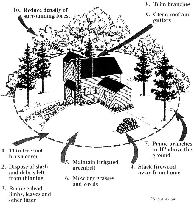
(Click for enlargement)
|
Recognizing the importance of the County's forests on our lives and the significance of the fire risk, the Trinity County RCD joined the Fire Safe Council when it was formed late last year. In the wake of the devastating Lowden Fire and the more recent Big Bar Complex of fires, the Trinity County Fire Safe Council is compelled to address all landowners in Trinity County. What occurred in Lewiston can very easily occur in your community. Whether a fire starts from natural causes such as lightening, or is human-induced as a result of a discarded cigarette, wood stove embers, a car's catalytic converter, or the lack of spark arrester on equipment, the fire risk in this county is intense. Fuel loads have built up over the past 40 years. When a fire does occur, it tends to be catastrophic rather than one that can be easily defended against. The costs and frequency of wild land fires are increasing.
The Lewiston fire dramatized this point all too clearly for us. Hopefully this disaster can have a silver lining, if it alerts other landowners to the fact that we can no longer be complacent about the situation. Fire risks increase as human encroachments expand in forested areas. It is time to stop talking about it and take action! We need to do everything we can to be prepared for fire.
The Fire Safe Council intends to do everything possible to keep homes and communities from being destroyed by fire. Planning and education are key to our mission. The Trinity County fire planning effort has multiple parts including: 1) Developing a strategic plan for the management of fire based on local expertise and the latest fire ecological science. This plan will use fire models and GIS for indications of where primary fuel breaks, staging areas, community protection perimeters, etc. should be located. This plan also will assist in prioritizing risk in order to indicate areas that can most effectively be treated and have the most impact in providing safer communities, 2) fuels reduction demonstration projects on private lands, 3) forest restoration, and fuels reduction demonstration projects on public lands, 4) implementation of the strategic plan, 5) coordination and enhancement of emergency response to protect assets at risk, and 6) public outreach and education.
| Meeting Reminders
|
Fire Safe Council Meetings
the fourth Thursday of each month
at the Weaverville Fire Hall at 7 pm.
|
South Fork Coordinated Resource
Management Planning Group
October 14—Weaverville Library
December 2—Fairgrounds, Hayfork
|
Trinity River Task Force
November 18-19
|
The Trinity County Fire Safe Council, with the support of the Trinity County Board of Supervisors, consists of local Volunteer Fire Departments, the Trinity County Planning Department, the Trinity County Resource Conservation District (RCD), the Watershed Research and Training Center (WRTC), as well as local representatives of California Department of Forestry and Fire Protection (CDF), US Forest Service (both Shasta-Trinity and Six Rivers), and Bureau of Land Management. Community organizations such as SAFE, Women in Timber, and Trinity Bioregion Group also are members. They have signed a Memorandum of Understanding to develop a coordinated program for fire management in the county by identifying high risk areas and undertaking strategic planning to reduce those risks on private and public lands using a locally-led planning process. If you are interested in this process, meetings of the Fire Safe Council are held on the fourth Thursday of each month at the Weaverville Fire Hall
at 7 p.m.
The Trinity County Fire Safe Council would like to encourage landowners to take a critical look at their property and take steps necessary to create defensible space around homes and to thin overstocked forested areas. The RCD and CDF have been working with a few neighborhoods that have expressed interest in making their areas safer. These include East Branch in Weaverville, Covington Mill, and Hyampom Road in Hayfork. We soon will be implementing similar demonstration projects with landowners in Timber Ridge (Weaverville) and Post Mountain (South of Hayfork), who have expressed interest in reducing the risk of fire in their community. The WRTC has implemented several projects to reduce fuels on US Forest Service lands. It is hoped that future treatments can be done on an integrated basis rather than a piecemeal one, so that the treatments will be as effective as possible in reducing the threat of catastrophic fire.
The Trinity Fire Safe Council recommends that landowners protect their homes and land by:
Creating adequate defensible space around structures
- minimize or eliminate tall grass, weeds and dense brush
- remove accumulations of woody debris, leaves, and pine needles
- replace highly flammable plants with fire resistant species
- remove trees, especially highly flammable ones, within 10' of structures
Breaking up the continuity of fuels
- Removing fuel ladders
- Irrigating the landscape around your home
- Stacking wood at least 100' away and uphill from the house and other structures
- Installing or replacing your address sign to be visible to firefighters
- Making sure roads are passable for fire fighting equipment
- Contacting CDF or RCD for more ideas on how to reduce the fire risk in your area.
Definitions*
Defensible Space is that area between a house and an oncoming wildfire where the vegetation has been modified to reduce the threat and allow firefighters to safely defend the house.
Fuel Ladders are created by layers of flammable material that allow a fire to move from the ground to the tree canopy.
Assets at risk includes homes and other structures, as well as forestland.
Fire risk is the chance of a fire starting based on several factors such as humans, their equipment, and their facilities.
Fuel condition is a combination of fuel size, quantity, arrangement, and the ratio of dead to live material.
Fire hazard is composed of fire risk, fuel condition, weather (including temperature, humidity and wind) and topography.
GIS - Geographic Information Systems are used to map and analyze landscape scale information such as fire risk and hazards.
* Excerpted from the CDF's, Forest Stewardship Program newsletter.
Return to This Issue's index.
|
Weaverville Basin Trail Committee
— Public Meetings
The Weaverville Basin Trail Committee held
two public meetings over the past few months
to obtain public input regarding the in-town
components of the trail system. This information
will be incorporated into the Weaverville Basin
Trail Master Plan being developed through
funds from the US Forest Service's Community
Economic Revitalization Team (CERT) program.
The Master Plan will help prioritize projects and
assist in the ability to obtain funds to implement
the projects.
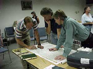
Supervisor Chris Erikson assisting
the design team with trail alignment
|
Approximately 60 interested citizens—hikers,
bicyclists, adjacent property owners and
motorcyclists — attended these two meetings
to provide input to the design team. The
participants had the opportunity to see some
broad concepts on what a completed trail
system could do to highlight the uniqueness and
beauty of the Weaverville Basin, including
historical and natural features of the area.
Discussion included the design of such key
features as trailheads, informational kiosks,
and various trail surfaces for different uses.
The Master Plan is expected to be completed
this month.
Sponsors of this project include the RCD, NRCS,
and the Resource Conservation & Development
Council.
Return to This Issue's index. |
TCRCD's No-till Drill
The Trinity County Resource Conservation District owns a Great Plains End-Wheel No-till Drill and we are encouraging landowners to discover the benefits the No-till drill can make on their properties.
The machine is designed especially for the over-drilling of pasture and the direct drilling of crop seeds and fertilizers. A variety of soil types, moisture and trash conditions can be tolerated with this equipment. The drill is 10' wide and about 10' long and pulls easily behind a truck (ľ ton or greater for steeper grades). The RCD charges a rental fee of $75 per day, making the drill a cost-effective tool.
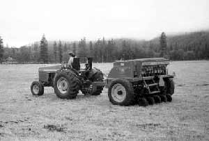
No-till Drill
|
Benefits of Conservation Tillage:
- Reduced labor
- as little as 1 trip for seeding compared to 2-3 for conventional tillage/planting.
- Improved long-term productivity
- carbon accounts for about half of the organic matter in the soil. The less you till, the more carbon you keep in the soil to build organic matter to promote future productivity.
- Improved water quality
- crop residues help hold soil particles and associated nutrients and pesticides on the field, cutting
- Reduced soil erosion
- minimizes soil disturbance.
- Decreased soil compaction
- reduced weight and horsepower requirements with no-till will minimize compaction.
- Improved soil tilth
- no till increases soil particle aggregation which makes it easier for water to move through the soil and allows plants to use less energy to establish roots.
Please call (530) 623-6004 for more information on the no-till drill.
Return to This Issue's index.
Covington Mill Fuels Reduction Project
The RCD obtained funds to implement a fuels reduction project and develop a strategic plan for the Covington Mill community from the California Department of Forestry and Fire Protection's (CDF) Forest Stewardship Project. This was submitted at the request of the neighborhood, many of whom have been concerned about the buildup of fuels and the high risk of fire.
The RCD has contracted with Ken Baldwin, a local Registered Professional Forester, to prepare a strategic plan for the area. He is working with CDF, the US Forest Service, Sierra Pacific Industries and area residents to gather relevant information to assess high risk areas in order to come up with a prioritized list of projects that should be completed to minimize the threat of fire in this community.
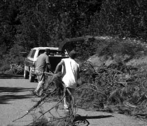
Charley Gacek and Jack McGlynn
chipping material cleared by Landowners
in the Covington Mill Community
|
As a pilot project, the RCD worked with participating landowners to reduce fuel loads and fuel ladders on private property around Guy Covington Drive. We had a tremendous response from the community (most likely the spate of recent fires in the county added to the interest). About 20 landowners worked to clear underbrush and fuel ladders on their property. The RCD then chipped the material that was piled up on the roadside. We had more people and material than anticipated, and with the current funds available, were barely able to complete the chipping of all of the material provided. With the success of this project, we hope to obtain additional funds to implement additional work and convince other neighbors to participate during the next phase of the project. There are now several great examples of what a good defensible space around a home should look like in this community and should serve as an example or model to other landowners and other communities in the county.
Other aspects of this project include implementing a buffer along Long Canyon Road and continuing outreach efforts with the Long Canyon and Lake Forest Communities encouraging participation in additional phases of fuels reduction efforts in this area of the county.
One of the landowner's who was instrumental in the success of this project, John Griffin, stated, "This has been very, very gratifying. The community members acted with great enthusiasm to get their neighborhood fire safe, and to help keep it from going up in smoke. We really look forward to the RCD getting additional funding to keep the project going next year."
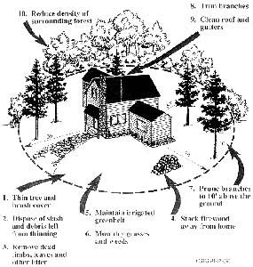
We have made significant headway, but additional work is necessary. The drawing on the front page of this newsletter depicts what we are aiming to achieve.
Return to This Issue's index.
Lowden Fire Rehabilitation — RCD's Role
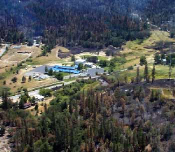
Lewiston Elementary School
|
The Bureau of Land Management (BLM) requested the assistance of the RCD to utilize local labor to implement restoration projects in order to rehabilitate the burned area of the Lowden Fire, which affected approximately 2,000 acres and adjacent downslope properties.
In August the RCD Board of Directors came to an agreement with BLM authorizing expenditures of up to $1.8 million dollars through federal fiscal year 2002 to implement several aspects of the Burned Area Emergency Rehabilitation (BAER) plan. The Board also agreed to be the local sponsor for the Natural Resource Conservation Service's Emergency Watershed Protection program for the fire in July.
These projects include:
- Rehabilitate handlines, dozer lines, drop points, staging areas, and unnecessary access roads which were a result of fire suppression activities.
- Remove debris from existing culverts and replace inadequate drainage culverts.
- Remove debris from basins.
- Remove residual floatable debris from channels and flood plains.
- Reforest by planting native (commercial) conifer species.
- Revegetate using a variety of native non-commercial species.
- Monitor reforestation, aerial seeding, and revegetation success.
- Inventory of private access roads for erosion problems.
A primary function of the RCD is to provide assistance to landowners. The RCD has a solid record of providing the types of assistance that will be needed in the coming months, and possibly years for the rehabilitation of the Lowden Fire burned area. We are the local agency with the expertise in revegetation, soil stabilization, and sediment control. Our experience in Grass Valley Creek watershed and with decomposed granite is important to the success of the rehabilitation effort. The RCD has a long history of working closely with the BLM and the other agencies that will be involved in the project. Community outreach and education also will be a critical task to assure that best management practices are used and maintained to protect private property and the natural resources in the area of the fire. The RCD has the experience and the tools to assist in this effort.
Return to This Issue's index.
District Manager's Corner
Pat Frost
As a property owner it seems like there
are always chores that need to be done.
They vary by the season, but they are
there every year. You all know what I am
talking about. How many of us; though,
include maintaining our property to reduce
the risk of fire? I am not just talking about
cleaning out the chimney, but really taking
a close look at the landscape that sur-
rounds our homes and making sure that
we have done what we can to provide a
defensible space.
The recent fires in Trinity County should
be a reminder that creating and maintain-
ing a fire safe environment is something
we all can do. This year Carol, my wife,
and I have been building a home. We
consulted with the California Department
of Forestry & Fire Protection. CDF has
simple, easy to follow guidelines that are
as important to our safety as any part of
the building code.
In this issue of the Conservation Almanac,
you will see examples from around the
county where your neighbors are planning
and implementing Fire Safe programs. In
Covington Mill, as in other rural residential
communities, the homeowners are working
with the RCD to create defensible space.
The Trinity County Fire Safe Council, a
group of concerned citizens and agencies,
is dedicated to designing a plan for safer,
healthier forests within Trinity County.
The Resource Conservation District has
been directing significant resources
towards the Fire Safety and Forest Health
issues in Trinity County – dedicated staff
like Charley Gacek and Jack McGlynn, who
spent several days working with the
residents in Covington Mill and Noreen
Doyas' unwavering efforts to find financial
support for fuels management projects. We
invite everyone in Trinity County to join us,
and to make a Fire Safe landscape a regular
part of your home maintenance.
Return to This Issue's index. |
Employee Feature
Helen Aunspach
Not many people can lay claim to starting a new job on April Fool's day, but that is what Helen Aunspach, the Trinity County RCD's new Fiscal Manager did. Helen was born and raised in Red Bluff, and attended Shasta College and later College of the Redwoods before entering the medical profession. Her work experience has been as varied as Napa State Hospital, Sempervirens in Humboldt County and the Trinity County Probation Department.
Helen and her husband, Joe, have been residents of Trinity County since 1990, but their attraction to our wonderful corner of California goes back many years. As avid kayakers, Helen and Joe were visiting Trinity County every spring and fall for many years to run the rivers. During those annual visits they began to look for, and eventually found, a special hide-away at Tangle Blue in the north county. The attraction to our peaceful, rural living grew stronger, until finally 9 years ago they gave up the hustle and bustle of places like Sonoma and Humboldt counties for full-time residency here.
This isn't the first time that Helen has worked at the RCD's offices on Horseshoe Lane. Her first job in Trinity County was with the Trinity County Rural Indian Health Clinic when it was located in these same offices. Most recently Helen worked at Trinity Hospital, as the Med/Surgical Unit Secretary. Helen's early training was in psychiatric nursing, and over time she developed an expertise in bookkeeping.
Helen has pretty much hung up her paddle. Now she dedicates her free time to gardening. She is an avid organic gardener, and has been developing an expertise in habitat gardening. "Habitat gardening is the blending of traditional gardening with the surrounding landscape, and emphasizes the use of native plants," Helen proclaimed with great enthusiasm.
When not tending her gardens or driving shuttles for her husband's kayaking runs, you just might see her renovating the homestead at Tangle Blue or keeping Gus, her pet goose, company.
Return to This Issue's index.
|
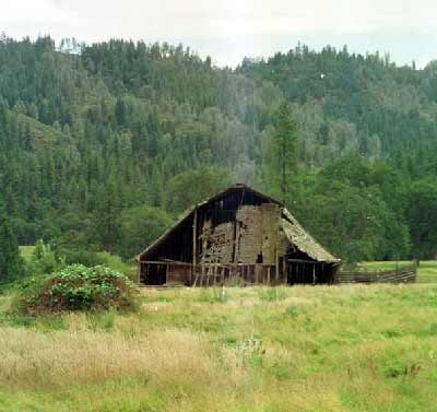
Glimpse From the Past
The remains of the East Fork Ranch Barn is located on the Wildwood Road at the junction of East Fork and Hayfork Creek.
This barn is on the large flat that was the site of the McCampbell home in the 1890's. A cluster of homes used to be located in this area.
Return to This Issue's index. |
Return to the Trinity County RCD Home Page
|